Social Studies
Government
Our next unit in social studies is about our government. This is a pretty long unit that we will start before winter break and then continue on with after the winter break. In this unit students will learn that a government is a group of people who lead a country, state or city. We learned that the president is the leader of our country, the governor is the leader of our state and a mayor is the leader of a city or town.
In this unit, our overarching question for the first part of this unit is why do people form government and why are they important? As well as understanding the consequences of the absence of rules and laws. We've already talked about how the government makes laws and decide if the laws are fair and make sure people obey the laws. We discussed how laws are there to keep us safe and to help ensure that everyone is treated fairly. The students had lots of ideas about what would happen if we had no rules or laws.
Students will also be learning about the United States Constitution and how it lists the basic laws of our country. We will learn how the constitution says that everyone has the right to be treated equally and that we have several rights. We learned that rights are freedoms that can't be taken away from us. A few of the specific rights we will talk about include freedom of speech, the right to vote for our leaders and the freedom of religion.
This unit will also cover what it means to be a good citizen and how it's important to be honest and responsible. We will discuss how if you are responsible, people can trust and depend on you. If you are not responsible, there could be consequences.
Coming up we will be learning about immigration and how immigrants can become United States citizens. In the meantime, enjoy these extra videos below that give more information about the purpose of government, the Constitution, the Bill of Rights and a fun episode from Liberty Kids (a great series that tells the history of the United States).
|
|
|
Immigration
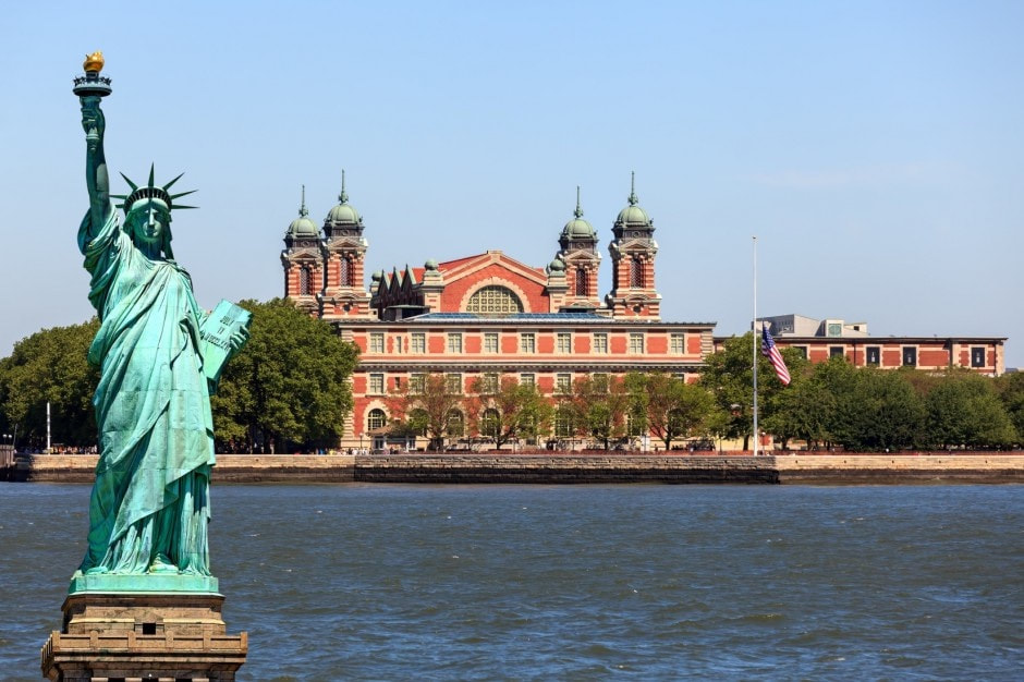
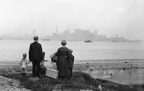
Our next unit in social studies will be all about immigration. In this unit, students will learn that if you live in the United States today, as some point, you or your relatives were immigrants - whether your ancestors came from Asia via Alaska 30,000 years ago, or whether your family emigrated from another country just a few days ago. The story of America is one of immigration. Students will learn that people came/come to America for many different reasons, such as escaping war, famine, persecution- or simply seeking a better life. Students will also learn that no matter when they arrived, and from where, that immigrants always faced grade obstacles, including finding employment and becoming citizens. Students will also learn about the immigration process through a virtual tour of Ellis Island in New York City. Towards the end of this unit, students will be able to experience what it was like to pass through Ellis Island. To read more about Ellis Island, the immigration process and the journey to Ellis Island, click here for a kid friendly website! Below you will also find a file to download that gives a good overview of immigration as well.
| immigration_past_and_present.pdf |
|
|
|
During our immigration unit we will learn about the reasons that immigrants came to America for a new life, what they packed and what their journey to America was like.
Why Leave?
Packing
Traveling to Port Cities
Journey to America
Why Leave?
- some left due to catastrophe's such as earthquakes and famines
- some left due to religious reasons. They wanted to be able to practice the religion they wanted to.
- some left to avoid being drafted into their country's army
- some left due to sickness, they mostly left to avoid getting sicknesses that were spreading throughout their country
- some just wanted to earn a better living and wanted to provide better for their family (money, food, shelter and school).
- Last, some left because land was cheap to purchase and there was a lot of land to buy
Packing
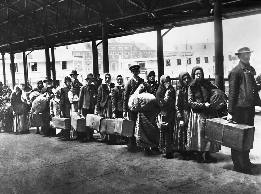
- Immigrants packed whatever they could carry
- some immigrants had suitcases and/or trunks, but those were mostly for first and second class. Most immigrants made bundles that they tied with string
- They brought quilts, mattresses and pillows
- some immigrants wore layers to avoid packing and carrying more items
- they brought food such as smoked sausage and ham, and dried fruit
- dolls and a few books were packed
- some immigrants packed their most prized jewelry that were family heirlooms or was expensive jewelry that they could sell along the way or once in America, should they need more money
Traveling to Port Cities
- Immigrants first had to travel to a port city where they could board a boat to America
- To get to port cities, immigrants used trains, boats and some even walked!
- Sometimes immigrants needed permits to get across borders of countries
- Immigrants also has to have money or possessions that they could use to bribe or pay their way across borders if they didn't have a permit
- They also had to be careful of thieves who could steal from immigrants while they were sleeping
- Once at port cities, immigrants sometimes had to wait weeks to leave
Journey to America
- if taking a steamship, travel could take anywhere from 6 to 32 days
- 1st and 2nd class passengers had their own private rooms
- most immigrants, were considered third class and were in steerage, which was the lowest level of the ship (below the water line)
- In steerage there were several hundred people, bunk beds (sometimes three high) lined the walls and there was only 1 bathroom, which consisted of a pot in the corner, which needed to be emptied several times a day by children.
- Food in steerage was lukewarm soup, boiled potatoes, stringy beef, herring (fish), bread and tea
- The journey over was dangerous because of shipwrecks, sickness, fires and weather
Ellis Island
In class, we will be using the Scholastic Ellis Island Interactive Tour, which can be found here. Through this website, we will explore all the stops that immigrants went through once they arrived at Ellis Island and what happened at each of these steps. Students should have a general idea of what happened at each stop. We will learn about the passage, the arrival (disembarking), the baggage room, the stairs to the registry room, the medical exam, legal inspection, detainees, the stairs of separation and the kissing post.
Stop 3 - Baggage Room
Stop 4 - The Stairs to the Registry Room
Stop 5 - Registry Room
Stop 6 - The Medical Exam
Stop 7 - Legal Inspection
Stop 8 - Detainees
Stop 9 - The Stairs of Separation
Stop 10 - The kissing Post
Stop 3 - Baggage Room
- Where immigrants checked and stored personal possessions
Stop 4 - The Stairs to the Registry Room
- Doctors stood on the second floor and watched to see how the immigrants came up the stairs and would look for signs of illness
Stop 5 - Registry Room
- Where the medical and legal inspections took place
- Officials in the great hall decided whether each person could enter the country right away or if they needed further review
Stop 6 - The Medical Exam
- Immigrants had a 6 second physical
- They were checked for limping, shortness or breath, red eyes, acting disturbed
- Immigrants clothing was marked if illness was found Ex. X = insanity, P = Pulmonary (lungs)
- If you passed the medical exam, you progressed to the legal inspection
- If you didn't pass, you were detained
Stop 7 - Legal Inspection
- The ship manifest was given to inspectors at Ellis Island
- Every immigrant was asked 29 questions
- Had interpreters to translate
- Could be detained for further questioning
Stop 8 - Detainees
- If you failed the legal or medical tests you were detained
- Legal detainees were housed on the 3rd floor dormitory. You could be detained for a few days or even a month! Legal cases were reviewed in the hearing room
- Medical detainees were sent to the hospital or quarantine (if contagious), medical detainees were given the chance to get better (could be days, weeks or months). There was a Board of Special Inquiry that would review individual cases to either allow immigrants in or send them back home.
Stop 9 - The Stairs of Separation
- 3 rows of staircases where immigrants were separated
- In the center was where detainees were
- to the right --> if they were traveling South or West
- to the left --> if they were traveling to NYC or North
- At the bottom of the stairs there was
- a post office
- ticket office for railways
- social workers for assistance
- exchange office - where you could exchange your countries money for U.S. Money
Stop 10 - The kissing Post
- nickname for the spot
- where family and friends waited for their loved ones
- where families hugged and kissed and greeted one another
Early American History
Our next mini unit in social studies was all about early American History. We learned about immigrants and colonists (people new to this country) who came over from Europe. We learned that as immigrants first came to America and set up their colonies, it made life harder for the Native Americans because these settlements and colonies were built on land that was owned and lived on by Native Americans for thousands of years. This lead to fighting between the colonists and Native Americans. It also lead to the deaths of many Native Americans, not only from fighting but from the diseases that settlers brought over with them.
We also learned about life for the colonists was hard at first as well. They had no real experience with the land and didn't know how to use the land appropriately. Some learned from local Native Americans, who were kind enough to help. As colonists learned more and more they started to clear more land for farms and houses. We also learned about the first 13 colonies that were set up.
We also learned about life for the colonists was hard at first as well. They had no real experience with the land and didn't know how to use the land appropriately. Some learned from local Native Americans, who were kind enough to help. As colonists learned more and more they started to clear more land for farms and houses. We also learned about the first 13 colonies that were set up.
Native Americans
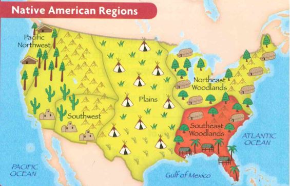
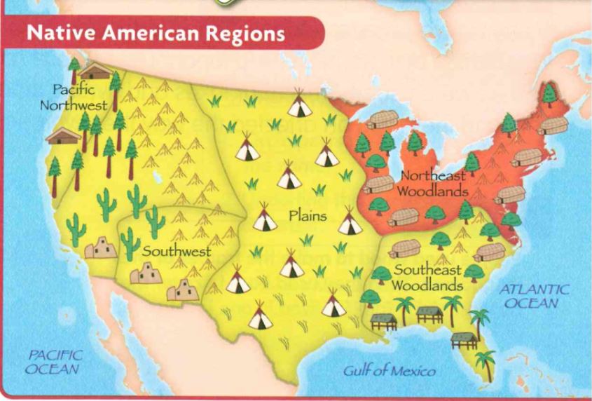
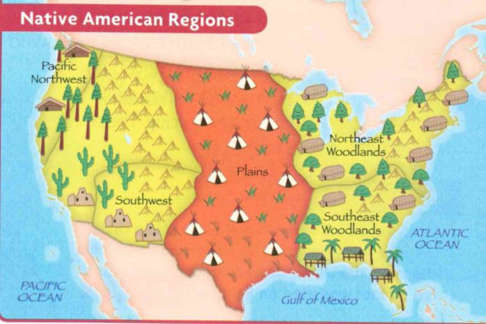
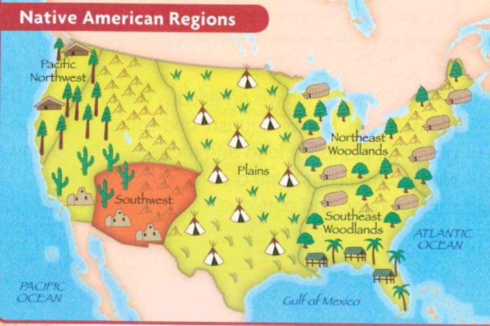
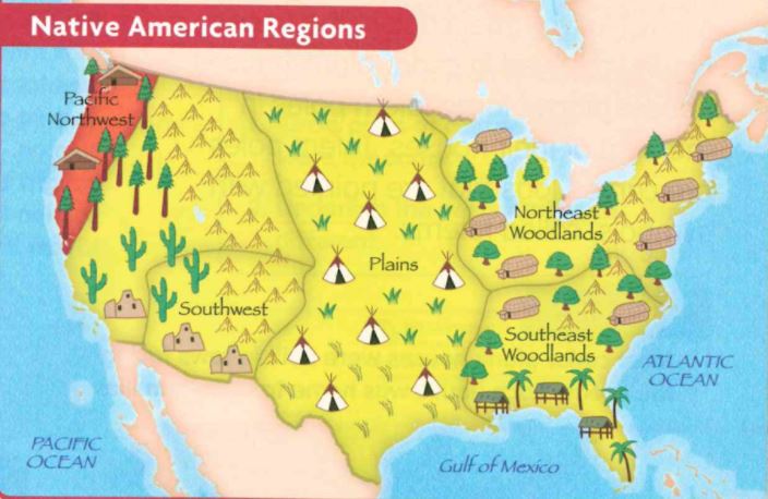
Our next unit will be all about Native Americans. We will be learning about the different regions of Native Americans in North America. There will be 5 regions that we will be learning about in North America. For each region we will be focusing on the homes, food, clothing, climate, lands, and tribes of the Native Americans living there. Check back for more information coming soon on each region we will be learning about.
The following are some vocabulary terms that your child will come across during this unit: feather, corn, tepee, longhouse, pueblo, canoe, buffalo, pottery, moccasins, lacrosse, farmer and weave.
The following are some vocabulary terms that your child will come across during this unit: feather, corn, tepee, longhouse, pueblo, canoe, buffalo, pottery, moccasins, lacrosse, farmer and weave.
Southeast Woodlands
Home
Land
Climate/Weather
Clothing
Tribes
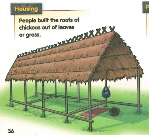
- Homes are called Chickees
- built from trees they cut
- floors were built up off the ground to protect from snakes and water
- sides were left open to let a breeze through and keep them cool
- roofs were made of leaves and grasses
Land
- full of plants, trees and animals
- North has mountains and rivers
- South has grass and swamp lands
Climate/Weather
- both the north and south regions were usually warm and rainy
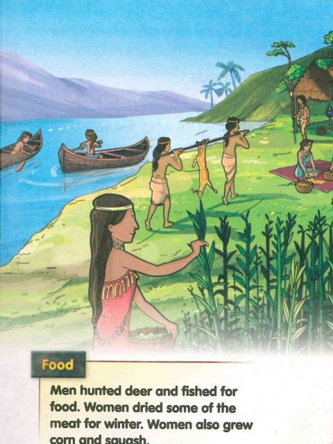
- Men hunted deer and fished for food
- Women dried meat for winter
- Women grew corn and squash
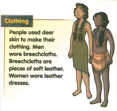
Clothing
- used deer skin to make clothes
- men wore breechcloths
- women wore leather dresses
Tribes
- Seminoles
- Cherokee
- Creek
|
|
Northeast Woodlands
Home
Food
Lands
Climate
Tribes
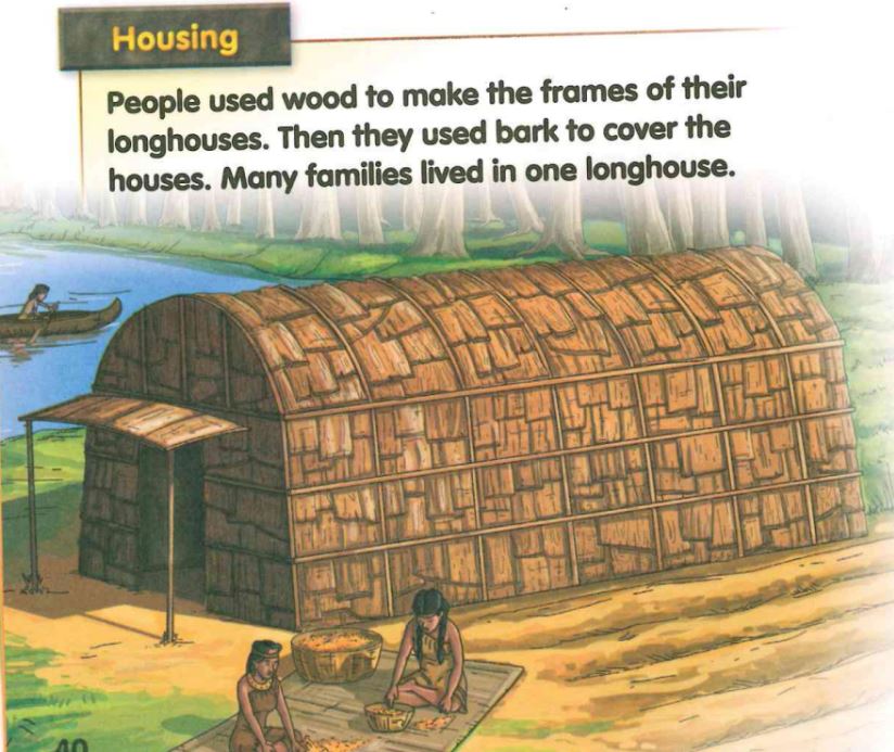
- houses were called longhouses
- built near lakes and rivers (due to food source and transportation)
- used wood and bark to build the longhouses
- many families lived in 1 longhouse
Food
- Men --> hunted and fished
- Women --> planted crops like corn, squash, and beans
- ate soups and stews
Lands
- very thick forests
- full of rivers, streams and lakes
- many plants and animals
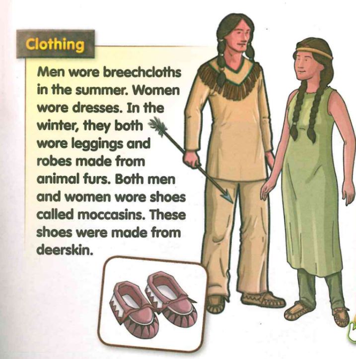
- Men in the summer wore breechcloths
- Women in the summer wore dresses
- In winter, both wore leggings and robes made from animal fur
- They wore shoes called moccasins, that were made from deerskin
Climate
- Summers are hot and humid
- winters are cold and snowy
- lots of rain
Tribes
- Powhatan
- Iroquois
|
|
Plains
Home
Clothing
Lands
Climate
Tribes/other
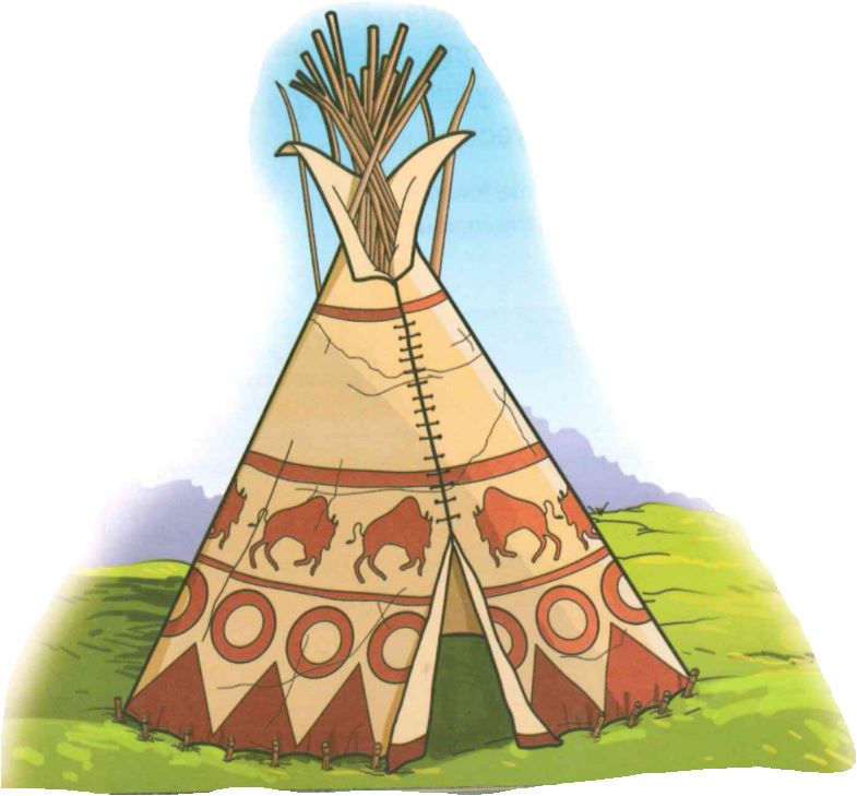
- homes called Teepees
- covered with buffalo skin
- triangular shape
- fire pit in the center, used for heat and light
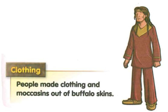
Clothing
- made from buffalo skins
- wore moccasins
Lands
- grasslands, valleys, streams and hills
- very few trees
- Prairie - flat land or rolling hills covered in grass
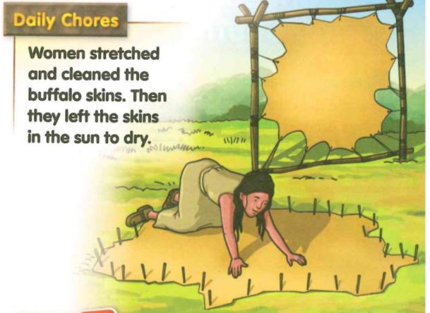
- Ate buffalo meat
- Dried buffalo meat
- Stew made from buffalo meat and vegetables. This was their favorite meal
Climate
- summers were hot
- winters were long and cold
- very little rain
Tribes/other
- Lakota
- Played drums and other instruments
|
|
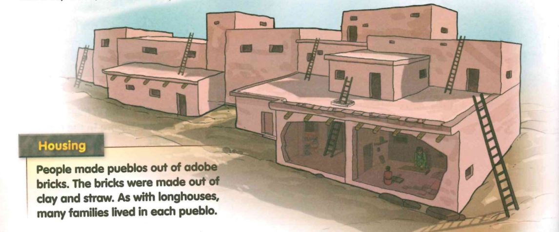
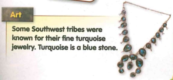
Southwest
Home
Clothing
Land
Climate
Tribes/other
- Homes called pueblo's
- had many levels, looked like an apartment building
- made from adobe bricks (clay/straw)
- many families lived in 1 Pueblo
Clothing
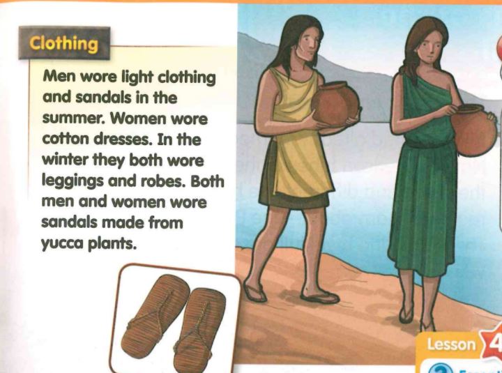
- men in the summer wore light clothing and sandals
- women in the summer wore cotton dresses
- In the winter, both wore leggings and robes
- sandals made from the Yucca plants
Land
- mostly desert
- very dry land
- planted corn, beans and squash
- hunted deer, rabbits and antelopes
- made stew from the hunted animals
Climate
- days were hot
- nights were cold
- very little rain fell
Tribes/other
- Pueblo Tribe
- Navajo Tribe
- gathered plants for medicine
|
|
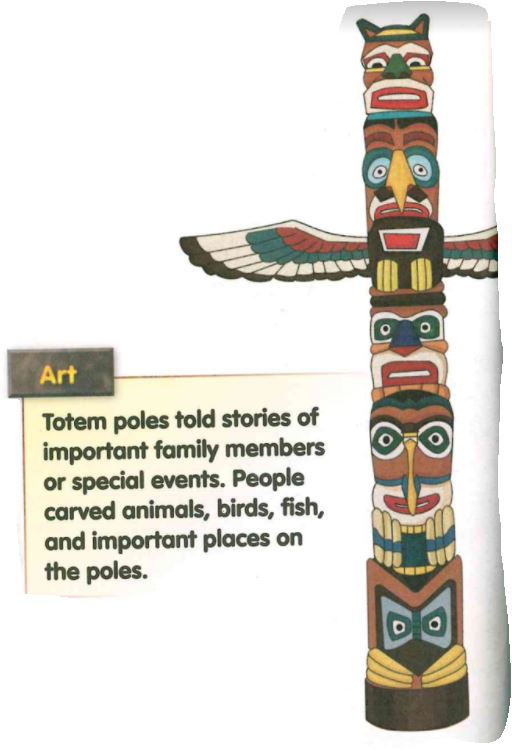
Pacific Northwest
Home
Clothing
Lands
Climate
Tribes/other
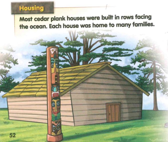
- Cedar plank houses
- had large totem poles in front
- houses were built in rows facing the ocean
- 1 house had many families
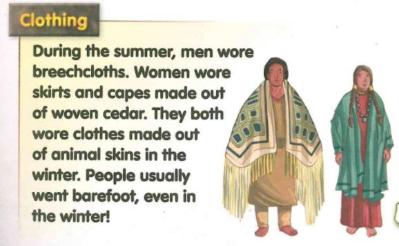
Clothing
- In the summer, men wore breechcloths
- In the summer, women wore skirts and capes made from woven cedar
- In winter, both wore clothes made from animal skins
Lands
- many trees and plants
- lots of food and natural resources
- oceans, rivers and rainforests
- made nets from cedar plank bark to catch salmon
- they caught enough salmon in Spring to last all Winter
- Salmon was their most important food
- for the rest of their food, they got from natural resources around them
Climate
- Summers were cool
- Winters were mild and wet
Tribes/other
- Tlingit Tribe
- Kwakiuti Tribe
- Totem poles are carved logs, that are carved with animals, birds, fish and important people and places.
|
|
Maps
Here's two video's that we watched in class that have really helped us learn more about where the world's continents and oceans are and how to remember them.
|
|
|
Here's a few extra video's you can watch for some more information!
|
|
|
|
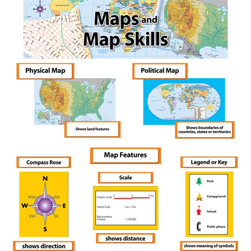
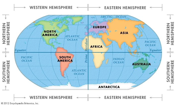
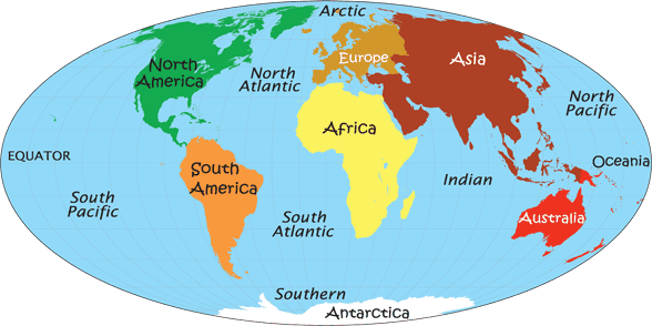
Our first unit in social studies is all about maps! In this unit students will be learning all about the different elements that a map has such as a map key or legend, scale, grid, etc, as well as why and how we use maps. By the end of this unit students need to be able to identify and label the 7 continents of our world and the 5 oceans of the world. Students also need to be able to name the 4 countries that make up North America (Canada, United States, Mexico and the Caribbean Islands). Additionally students need to be able to recognize and label the state of Florida within the United States and know that Tallahassee is the capital of Florida. A great way to continue to learn about Maps is to re-read the Social Studies Weekly Magazines that are coming home with your child. Below you will also find some extra practice pages that you can use about maps.
Important vocabulary words for this unit are as follows:
Map: A drawing that shows where places are located
Thematic Map: tells us certain information about a place or area (ex. neighborhood, theme park)
Map Scale: shows how far apart places really are on a map (ex. 1 inch = 1 mile or 1 inch = 25 miles)
Title: Maps have titles so you know what kind of map you are looking at and what information you can get from it
Compass Rose: cardinal directions, North, South, East, West
Intermediate Directions: on some compasses, Northeast, Southeast, Southwest, Northwest. These directions are halfway between each of the cardinal directions
Map Key: tells what the pictures on a map mean, also called a legend
Coordinates: numbers or letters (or both) along the margins (sides) of a map that help you find places
equator: an imaginary line that runs west to east and divides the globe into two hemispheres: Northern and Southern Hemisphere
Prime Meridian: an imaginary line that runs north to south and divides the globe into two hemispheres: Western and Eastern Hemisphere
Extra Resources
|
|
| ||||||
|
|
